THE CRYSTAL RIVER
Perhaps it’s where your tap water comes from? Or your irrigation water? Or both?
Do you appreciate its wild wonders, explore its scenic history, or enjoy its playful waters?
Do you live along its banks? Full time? Part time? In spirit?
It is wild. It is scenic. It is home.
And it is...
Do you appreciate its wild wonders, explore its scenic history, or enjoy its playful waters?
Do you live along its banks? Full time? Part time? In spirit?
It is wild. It is scenic. It is home.
And it is...
THREATENED.
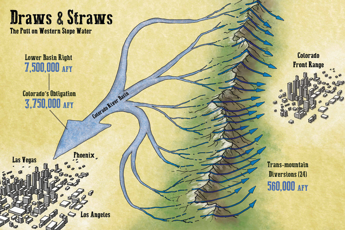
Colorado currently has 24 trans-mountain diversions sending five-hundred-sixty-thousand acre feet per year from the western slope to the front range.
That’s 182 billion gallons, or over half-a-million football fields filled one foot deep with water – EVERY year. Our state also has an obligation to send three-million-seven-hundred-fifty-thousand acre feet (or 1.2 trillion gallons) per year downstream to lower basin states... allocations we are clearly struggling to meet. |
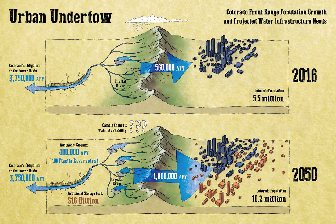
Today, 40 million people depend on the Colorado River's water for agricultural, industrial, and domestic needs.
Some estimates predict it will one day be asked to support twice that population. In Colorado, our population is projected to nearly double by 2050, suggesting a need for a lot more water – particularly for the Front Range. Where will this water be sought? Where the water is. Colorado’s western slope. Our home rivers. |
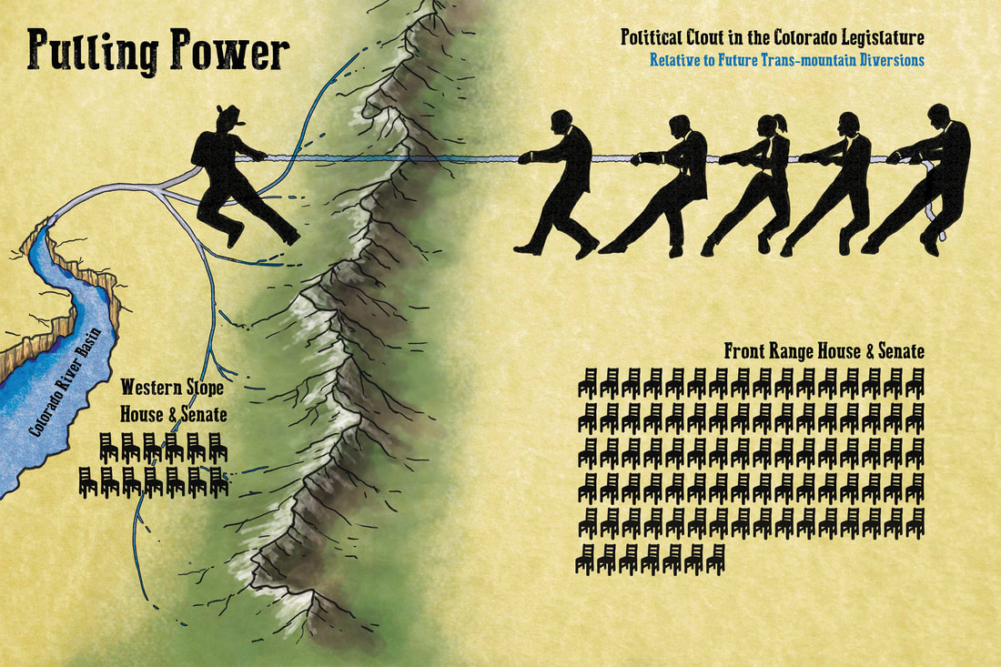
The water world has many powerful voices – developers, agencies, and legislators – who view new storage projects as the primary solution to the western water crisis.
They ask, “Where can we store? What can we dam? Where can we divert?” The Crystal River remains one of very few large streams in our state that still has neither a dam or trans-basin diversion. It has long been a target. |
|
In fact, dams and trans-basin diversions have threatened the Crystal for well over a century.
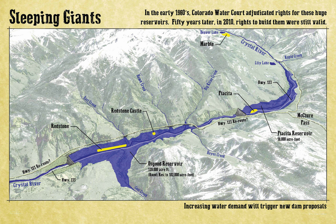
As early as 1905, ranchers south of Silt considered supplementing Divide Creek’s irrigation capacity with trans-basin diversions from the Crystal River. In 1909, an engineer from Denver named Peter O’Brian filed a map with the state water court illustrating a plan to take water from the Crystal River to the Divide Creek area. O’Brian called his project The Garfield County Ditch. He hoped to divert 1,000 cubic feet per second from the Crystal River for, “irrigation, domestic, storage and power purposes” on the dry mesa tops south of Rifle. Thankfully, it was cost prohibitive and never built. Then came America’s age of mega-dams. In 1956, Congress approved the Colorado River Storage Project Act authorizing Glen Canyon, Flaming Gorge, Navajo, Blue Mesa, Paonia and several other large dams throughout the Colorado River Basin. On the Crystal River, the legislation prioritized planning for a major dam and trans-basin diversion project… the specter of which would haunt the Crystal for the next 55 years. By 1957, the project developers had successfully filed for conditional water rights to build two large dams on the Crystal River. The project initially threatened two large dams on the Crystal River. Their names were Placita and Osgood. Each was to stand 280 ft. tall with hydropower facilities and 1,000 cfs of throughput capacity. Together holding twice the volume of Ruedi Reservoir – they would have inundated much of the Crystal River Valley under two huge reservoirs of water and mud. Redstone and Placita would have ceased to exist. |
Project plans were revised several times between the 1960’s and early 1980’s - yet seemed to fizzle when a 1982 planning report concluded the dams were, “not economically justified.”
The plans lay dormant for nearly 30 years. Then, in 2011, project owners shocked the Crystal Valley with new maps showing Osgood and Placita Reservoirs as real possibilities once again. Fortunately, an organized community opposition – paired with unfavorable economics – won the day. The dams’ developers, facing the prospect of an adverse water court ruling, sought a settlement. In 2013, an agreement was reached. It allowed the developers to preserve their water rights in exchange for abandoning most of their project rights within the Crystal River basin. The project owners declared the decision “was largely driven by cost concerns,” also citing “localized opposition.” The last line their press release stated the settlement preserves the opportunity for the developers to, “file new, junior water rights (both storage and direct flow rights) in the future.” Ominous words foretelling an unfortunate truth… |
BAD IDEAS IN RIVER DEVELOPMENT, NEVER. GO. AWAY.
Over-allocation. |
It’s only a matter of time before the next major water development project comes calling.
The hard truth is… our community may not prevail against the next variant of this threat. Whether from east or west, dam or diversion, the next evolution of river grab is likely to be forced upon our small community – either by billions-backed outside interests, or a new age of federally decreed dam building. The deck is stacked against the Crystal River’s free flowing future. Our community has but one card, one tool, one chance, to compete at the most formidable level of this high stakes game... |
WILD & SCENIC RIVER
DESIGNATION
Locally customized protection against apex level river predators.Only an act of Congress can prevent the future possibility of a federally decreed dam.
The National Wild and Scenic Rivers Act of 1968 was designed to do just that – to preserve certain rivers – those with outstanding natural, cultural, and recreational values – in a free-flowing condition for the enjoyment of present and future generations. The Act is locally customizable to meet the specific needs of individual rivers and their communities. The pursuit of Wild & Scenic designation for the Crystal River was initiated by a group of local citizens in the late 1960’s. This grassroots campaign was forged in the foundations of our community. It has grown for over 50 years – in lock step with the threat. |
|
THREE STEPS TO PROTECT IT
There are three steps to gaining Wild & Scenic designation for a river:
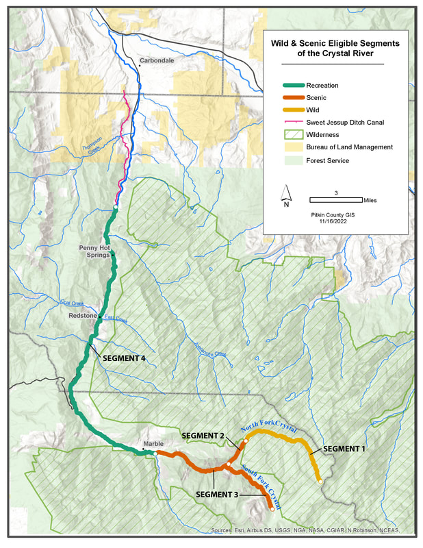
1) EligibilityThe White River National Forest has (twice) determined the upper 39 miles of the main stem of the Crystal River (from the headwaters to the Sweet Jessup irrigation canal) meet the standard for inclusion in the Wild & Scenic River system.
You can read the full results of the study here: https://www.fs.usda.gov/Internet/FSE_DOCUMENTS/stelprdb5286435.pdf |
2) SuitabilityThe Wild & Scenic Act can be locally customized to meet the specific needs of individual rivers and their communities.
The Crystal River Valley community is currently engaged in a collaborative planning process which will:
|
3) LegislationImplementing Wild & Scenic river protections requires legislative action by the U.S. Congress.
This third and final step comes at the end of the process. It would formally designate a specific reach of the Crystal River as a protected component of the National Wild & Scenic Rivers system. |
ELIGIBILITY
The Forest Service classified the 39 Wild & Scenic eligible miles of the Crystal into four river segments as follows:
|
WILD Free of impoundments and generally inaccessible, except by trail. Their watersheds and shorelines are essentially primitive with unpolluted waters. These represent vestiges of primitive America. SCENIC Free of impoundments. Their watersheds and shorelines are still largely primitive and undeveloped, but accessible in places by roads. RECREATIONAL Readily accessible by road or railroad. They may have some development along their shorelines and may have undergone some impoundment or diversion in the past. |
Segment 1 – Wild From the headwaters of the North Fork downstream to the Maroon Bells-Snowmass Wilderness boundary (~7 river miles) Segment 2 – Scenic From the wilderness boundary on the North Fork to the junction with the South Fork (~2 miles) Segment 3 – Scenic From the headwaters of the South Fork downstream to Beaver Lake (~10 river miles) Segment 4 – Recreational From Beaver Lake downstream to the Sweet Jessup headgate (~20 river miles) |
DESIGNATION...
DOES
|
DOES NOT
|
THE TIME IS NOW!
|
|
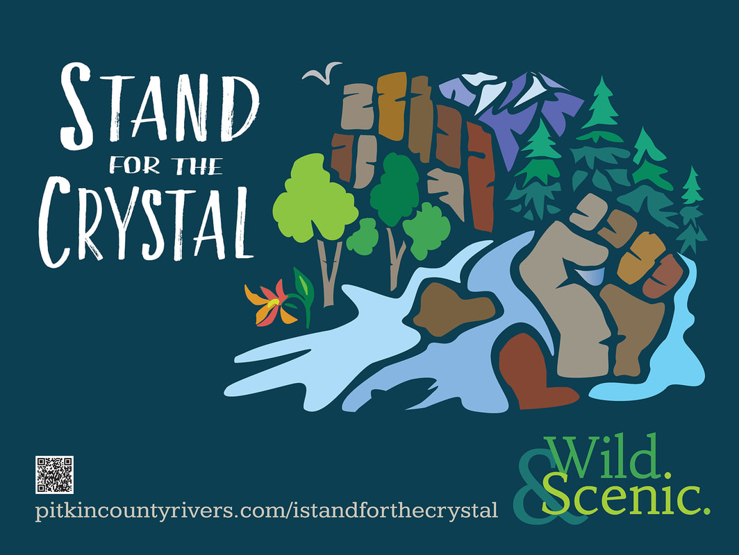
Please stand with us!The Crystal Valley community must work together to ensure the Crystal River remains a free-flowing, healthy and natural river with no dams or diversions out of the watershed.
New water interests WILL challenge the future of our valley. Next year? Next week? Tomorrow? There is no way of knowing when the opportunity to protect the Crystal may be lost… FOREVER. |
Take the Flow Free Forever pledge!
Stand for its wild ways. |

#CrystalWild #IStand4TheCrystal #FlowFreeForever
THE CRYSTAL RIVER COMMUNITY THANKS YOU!